[vc_row css=”.vc_custom_1529688263758{padding-top: 80px !important;padding-bottom: 80px !important;}”][vc_column offset=”vc_col-lg-offset-0″][ultimate_heading main_heading=”SERVICES” heading_tag=”h1″ main_heading_font_size=”desktop:40px;” main_heading_line_height=”desktop:50px;” sub_heading_line_height=”desktop:28px;”][/ultimate_heading][/vc_column][/vc_row][vc_row full_width=”stretch_row” equal_height=”yes” bg_type=”bg_color” css=”.vc_custom_1588097699559{padding-top: 50px !important;}” bg_color_value=”#eaeaea”][vc_column css=”.vc_custom_1529671385255{background-position: center !important;background-repeat: no-repeat !important;background-size: cover !important;}”][vc_column_text]Our services target people, communities, organizations, companies that need to generate information about water and nature, implement nature-based solutions and/or live experiences in nature, particularly in remote environments: generation of data, applied research and development of sustainable solutions, monitoring, installation of equipment, exploration and discovering; as well as transfer and share information and experiences.[/vc_column_text][/vc_column][/vc_row][vc_row full_width=”stretch_row_content_no_spaces” equal_height=”yes” bg_type=”bg_color” css=”.vc_custom_1583534133283{padding-top: 0px !important;padding-bottom: 80px !important;}” bg_color_value=”#eaeaea”][vc_column css=”.vc_custom_1583611414016{background-position: center !important;background-repeat: no-repeat !important;background-size: cover !important;}”][vc_row_inner css=”.vc_custom_1529671037502{margin-right: 30px !important;margin-left: 30px !important;}”][vc_column_inner width=”1/4″ css=”.vc_custom_1529671526513{padding-right: 25px !important;padding-bottom: 50px !important;padding-left: 25px !important;}”]
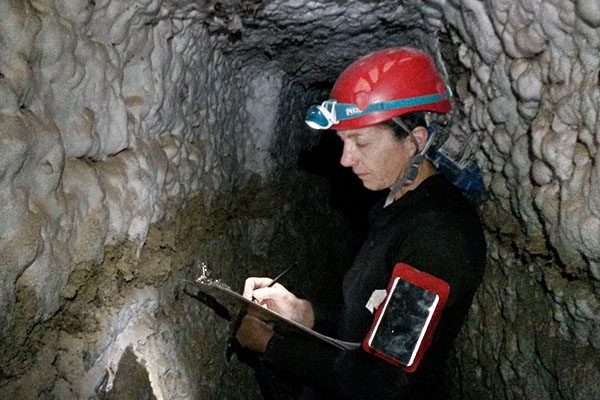
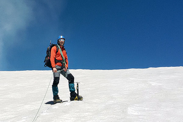
Carpe Science makes available to scientists, companies, public institutions, communities or anyone interested, reliable and otherwise unobtainable data: samples (water, soil, vegetation, geological formations, snow, etc.), measurements of variables, pictures or video, etc. Our team has extensive experience in the generation of information and data collection in nature (continental areas), especially in remote and difficult to access areas: high mountain terrain, deserts, glaciers and underground (cave, gallery, etc.). Our quality of scientists and outdoor experts allows us to access areas only accessible on foot and/or through special techniques and equipment.[/vc_column_text][/vc_column_inner][/vc_row_inner][/vc_column][/vc_row][vc_row css=”.vc_custom_1588176204437{margin-top: -50px !important;}”][vc_column][vc_single_image image=”51054″ img_size=”full” alignment=”center”][/vc_column][/vc_row][vc_row css=”.vc_custom_1588176247489{margin-bottom: 100px !important;}”][vc_column width=”3/4″][bsf-info-box icon_size=”32″ title=”1. Installation, operation and maintenance of monitoring stations:” heading_tag=”h4″]
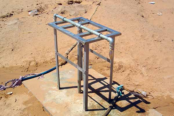
1.1. Installation of monitoring stations.
This service offers the installation of monitoring station (meteorological, gauging, piezometric, water quality stations or other variable). Depending your needs, we can include:
- An assessment to determine the optimal location of the station(s). The methodology depends on the context. For more information about our experience in hydrometric network design, [see->] Lictevout, E. & Gocht, M. (2017). Hydrometric network design in hyper-arid area. Hydrology Research 49 (4) 1208-1220.
- Advice for selecting equipment (sensors, datalogger, etc.);
- Installation in remote areas (deserts, high mountains, glaciers, underground galleries, caves, etc.).
1.2. Operation and maintenance of monitoring stations.
This service offers the operation and maintenance of monitoring stations, including in remote environments (deserts, high mountains, glaciers, underground galleries, caves, etc.).
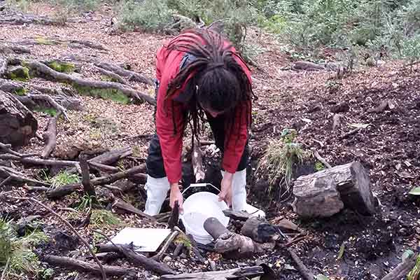
[/bsf-info-box][/vc_column][vc_column width=”1/4″][vc_single_image image=”51048″ img_size=”full” onclick=”custom_link” img_link_target=”_blank” link=”https://carpescience.com/wp-content/uploads/2019/05/Instalaciones2_CS_559.jpg”][/vc_column][vc_column][vc_row_inner css=”.vc_custom_1588111738772{margin-top: 40px !important;margin-bottom: 40px !important;}”][vc_column_inner][vc_separator color=”custom” el_width=”70″ accent_color=”#008c8c”][/vc_column_inner][/vc_row_inner][vc_row_inner][vc_column_inner width=”1/4″][vc_single_image image=”2656″ img_size=”423×423″ onclick=”link_image”][/vc_column_inner][vc_column_inner width=”3/4″][bsf-info-box icon_size=”32″ title=”2. Data and samples collection in remote areas and difficult access:” heading_tag=”h4″]This service offers sample and data collection: geological samples, water samples, snow, soil, vegetation etc.
We apply national and international protocols and standards for each type of sample, which ensures the validation and scientific publication of the data.
We access remote areas, only accessible on foot or through special techniques or equipment. We also offer services in totally isolated areas and only accessible by air. Depending on the needs, the use of Carpe Science measuring equipment (multiparameter probe, water level probe, flowmeter, etc.) can be included. All our equipment has international calibration certification.
[/bsf-info-box][/vc_column_inner][/vc_row_inner][vc_btn title=”DO NOT HESITATE TO CONTACT FOR FURTHER INFORMATION” style=”3d” color=”success” align=”center” button_block=”true” link=”url:https%3A%2F%2Fcarpescience.com%2Fen%2Fcontact%2F|title:Contact||” css=”.vc_custom_1588623802684{margin-top: 10px !important;}”][/vc_column][/vc_row][vc_row bg_type=”image” parallax_style=”vcpb-vz-jquery” bg_image_new=”id^2732|url^https://carpescience.com/wp-content/uploads/2019/06/Deporte_CS_1900.jpg|caption^null|alt^null|title^Deporte_CS_1900|description^null” bg_image_repeat=”no-repeat” bg_override=”ex-full” css=”.vc_custom_1588619890216{padding-top: 100px !important;padding-bottom: 100px !important;}” el_id=”exploration_en”][vc_column width=”2/5″ css=”.vc_custom_1588177160143{padding-top: 40px !important;padding-right: 40px !important;padding-left: 40px !important;background-color: rgba(247,148,29,0.75) !important;*background-color: rgb(247,148,29) !important;}”]
Currently we run 2 projects to discover nature, click on them for more information [in Spanish]:[/vc_column_text][vc_row_inner css=”.vc_custom_1588249771850{margin-bottom: 10px !important;padding-bottom: 5px !important;}”][vc_column_inner][vc_btn title=”Courses” style=”3d” align=”center” button_block=”true” link=”url:https%3A%2F%2Fcarpescience.com%2Ftransferencia%2Fcurso-asistente-monitor-ican-may20%2F|title:Curso%20Asistente%20Monitor%20Canyoning%20ICAN%202020|target:%20_blank|”][vc_btn title=”Canyoning Program” style=”3d” align=”center” button_block=”true” link=”url:https%3A%2F%2Fcarpescience.com%2Fservicios%2Fexploracion-naturaleza%2Fcanyoning%2F|title:Programa%20Canyoning%20Chile|target:%20_blank|”][/vc_column_inner][/vc_row_inner][/vc_column][vc_column width=”3/5″][/vc_column][/vc_row][vc_row css=”.vc_custom_1588619961204{margin-top: 40px !important;margin-bottom: 40px !important;}” el_id=”studies”][vc_column][vc_row_inner css=”.vc_custom_1583507182417{margin-top: 40px !important;}”][vc_column_inner width=”3/5″][ultimate_carousel slide_to_scroll=”single” slides_on_desk=”1″ slides_on_tabs=”1″ slides_on_mob=”1″ arrow_color=”#008c8c”][vc_single_image image=”51059″ img_size=”full” alignment=”center”][vc_single_image image=”51063″ img_size=”full” alignment=”center”][vc_single_image image=”51062″ img_size=”full” alignment=”center”][vc_single_image image=”51061″ img_size=”full” alignment=”center”][vc_single_image image=”51065″ img_size=”full” alignment=”center”][/ultimate_carousel][/vc_column_inner][vc_column_inner width=”2/5″ css=”.vc_custom_1583508573111{padding-left: 40px !important;}”]
We carry out project evaluations in relation to water resources:
- Evaluation of research and development projects proposals.
- Evaluation of research and development projects.
- Evaluation of humanitarian and development projects in water and sanitation, WASH (WATSAN).
Examples of projects evaluated:
- Evaluation of R&D proposals for different ANID (ex CONICYT) financing lines.
- Evaluation of water and sanitation projects financed by UNICEF in Haiti in the framework of the emergency response to Hurricane Matthew.